The effects of climate change, compounded by those of the July 2 passage of Hurricane Elsa, have caused significant damage to Barbados’ east coast. Gone are the wide sandy beaches that once wrapped around the east coast and the rich vegetation that trimmed the outer perimeters, a mixture of sea grape, pusley and other plants designed to hold the sand together.
Instead, there is exposed beach rock where sand once was. Sargassum now covers the sand, and much of the vegetation has been lost. The sand dunes and nearby properties are also under threat.
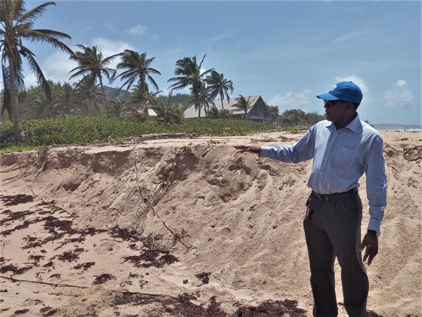
That section of the coastline, once loved by surfers and those who simply ventured there to get away from their daily life, remains battered, and a treacherous stretch for even the boldest person to venture.
During an interview with the Barbados Government Information Service, Director of the Coastal Zone Management Unit (CZMU), Dr. Leo Brewster, explained that his department was working to determine what measures could be put in place to mitigate the situation.
Noting that there was a significant loss of vegetation from storm surge, the Director said that it had an impact on the sand dunes as waves continued to penetrate more inland, also reducing the size of the beach.
“The unfortunate reality with the east coast is that it has a very short shelf life. In essence, the nearshore area goes off flat to gently sloping and then it drops off very deep…. So, therefore, once this sand is lost, it is lost permanently. It just goes into the abyss and therefore will not return as you would find on the west coast or the south coast of the island,” Dr. Brewster said.
“The unfortunate reality with the east coast is that it has a very short shelf life. In essence, the nearshore area goes off flat to gently sloping and then it drops off very deep…. So, therefore, once this sand is lost, it is lost permanently.”
CZMU Director, Dr. Leo Brewster
These issues are placing neighbouring properties at risk from coastal hazards and storm surge as the size of the beach has contracted significantly.
He explained that in some instances, between 15 and 20, and as much as 30 metres of beach was lost to erosion, representing a “sizeable chunk” at the east coast.
The Director stressed that was one of the primary reasons why his department insisted on developments along the east coast having setbacks as far back from the ocean as possible.
But, he lamented that within the last five to seven years, properties have been trying to push the boundary by coming forward. “Some of those properties that did push forward have really put themselves at risk from coastal hazards and storm surge in the near future, as we see it,” Dr. Brewster said.
Now, the concern for coastal officials is the fact that hard engineering interventions to combat erosion could cause even more damage. “Once you get these hard structures…and the waves start beating on them, it is going to cause further erosion along a section of coastline, that naturally is to have a significant buffer and a significant vegetative line for protection,” he said.
As a result, the Director suggested that natural vegetation such as sea grapes and fat pork vines be considered as they were very effective in maintaining the mini sand dunes essential in preserving that section of the coast.
He pointed out that his department would engage in discussion with the National Conservation Commission and the Soil Conservation Unit to see what initiatives could be used to ensure the sand dunes are protected and maintained.
However, the problems being experienced are also being compounded by mounting piles of sargassum seaweed on the coast as erosion of the sand is also occurring beneath the algae.
“When that sand is removed, it is taken into the back wash outflow and then it is removed from the system as sargassum is taking its place…. It means that it cannot come back in and therefore you get the narrowing of the beach through sargassum erosion.”
CZMU Director, Dr. Leo Brewster
Dr. Brewster explained that large algal mats or large influxes of sargassum caused waves to ripple beneath it, resulting in the beach being continuously eroded as they penetrated further inland.
“When that sand is removed, it is taken into the back wash outflow and then it is removed from the system as sargassum is taking its place…. It means that it cannot come back in and therefore you get the narrowing of the beach through sargassum erosion,” the Director said.
However, he outlined that the new Integrated Coastal Zone Management Plan insisted on a minimum 30-metre setback from the coastline, and even larger on the east coast because of the wave energy found on that section of the island.
Dr. Brewster further stated that a 200-metre landscape buffer was also incorporated into the plan, which was in existence from the 1998 plan. “Those two setbacks try to ensure that any form of development is pushed well back from any damage from wave attack and storm surge,” the Director noted.
He also stressed that the CZMU was working to ensure those setbacks were maintained because of the present condition of the environment.