Barbados latest rainfall & air temperature situation & projection over the next few months
Current situation
Rainfall
There has not been much change in the current situation on the ground with respect to the very dry top soils across parishes such as St. Philip, Christ Church, Southern St. John, Southern St. George, most of St. Michael as well as Southern St. James. Vegetation is expected to continue to struggle for a few more weeks as we head into the official start of the Hurricane season.
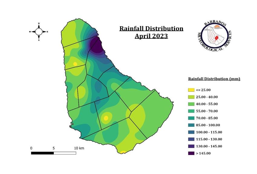
Areas of higher elevation such as St. Thomas and St. Andrew for example, vegetation remains fair to good.
Temperature
Air temperatures across the island have also been on the rise over the past few weeks ( as is expected ) with indications that this year will be warmer than last year from a model perspective and supported by actual observations.
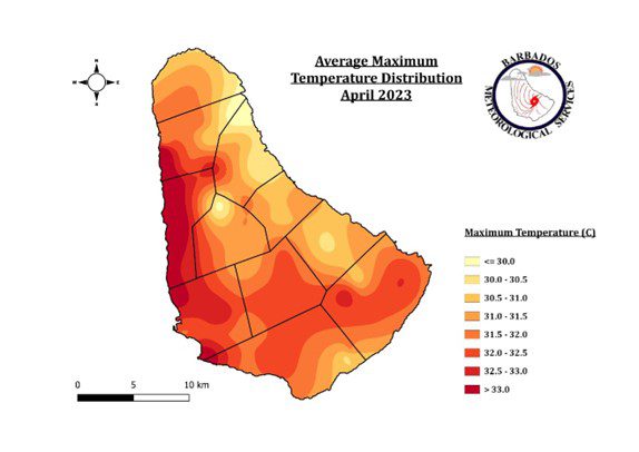
For the first eleven days of May 2023, peak temperatures at Charnocks Christ Church have been well above the 30-year average of 30.6 and hovers around 31.1 ˚C.
| 2023 | Avg. Max Temp | 30-Yr Avg |
| May 1-11 | 31.1 ˚C | 30.6 ˚C |
Rainfall & Temperature Outlook

Latest short-term climate forecast from the BMS for rain accumulation over the next few months (up until August) is predicted to be around normal to just above average. This latest forecast suggests that aquifers in some areas may recharge slowly over the next few months and thus water conservation methods recommended by the BWA should be adhered to over the next few months.

The warmer air temperatures we are experiencing now and leading up to the next few months will mostly be attributed to the warmer sea surfaces temperatures across the Atlantic basin. From the image above, every month is predicted to be warmer compared to last year with the exception to August, where there is not much change expected. Of high interest is the predicted peak temperatures for September 2023. BMS official predictions at this point is suggesting peak temperatures in urban (Bridgetown) and western areas to be around 32˚C to 35˚C, an increase from 31˚C to 34˚C observed in 2022.
In summary, we are expecting rains to slowly pick up from June along with very warm temperatures compared to last year. Note, these predictions can change, and therefore an update will be given each month.
Impacts
- Significant impacts to rainfed crops particularly across the south of the island
- Large field fires are highly possible up until June mainly across the dry southern sections of the island. ( St. Philip, Christ Church, St. Michael, Southern St. George)
- Foliage is expected to remain very poor across the south of the island and fair to good in higher elevations for grazing livestock.
- Some nights will become a little uncomfortable due to the warm temperatures in the late evening.
What you should do to help mitigate the impacts?
- Continue to follow public announcements issued by the Barbados Water Authority.
- Use crops that handle dry and low rainfall conditions better over the next few months.
- Look after livestock especially in dry parched fields by supplying adequate fresh drinking water and fodder. The supply of fresh water will become more critical during the midsummer month of September. Check cooling system(s) for your livestock (such as poultry) to ensure that you have effective system(s) in place to provide relief to livestock during heat periods.
- Use other best recommended practices prescribed by the Ministry of Agriculture and Food Security.
- Remember to stay hydrated and plan well ahead for the upcoming warm months. Use other recommendations and tips from the Ministry of Health and Wellness.